Rajasthan: Curse of a Canal on Agriculture in Luni Delta
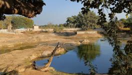
Overflow of water being released from the main Narmada canal into the Luni River (Photo - Satish Malviya, 101Reporters)
Jalore/Barmer, Rajasthan: Jagdish Kadwasra’s (52) fields are a sight to behold, with pink flamingos speckled over the 2.25-hectare (ha) wetland. But Kadwasra had to pay a huge price for this view. It was imposed upon him. The land once produced cumin, before it was submerged. “I am learning to find joy in the birds now,” he said.
Kadwasra is a resident of Sesawa village in Rajasthan’s Jalore district. More than 2000 ha of land in and around his village are slowly turning into a salt marsh. The canal network from the Narmada River, once welcomed by these villages as a lifeline, is now their biggest pain. “The canal started in 2008. We started cultivating wheat and mustard after that. Earlier, it was only cumin as it is rainfed and can take some brackish water too. But seepage from the canal led to waterlogging in our fields,” said Kadwasra, who owns 25 ha of land in the region.
In the nearby Agarawa village, Ganga Ram Chaudhary (70) also lost half of his 100-ha land to waterlogging. “Whenever excess water is released from Panuariya Sub-minor (the canal near his village), it fills our fields. This has been going on since 2012,” said Chaudhary.
“Before the canal, people migrated due to drought; now they are migrating due to waterlogging and salinity,” he lamented.
At 458 km, the Narmada canal network is the second longest in India and the largest by water carrying capacity. Jalore and Barmer districts in South-Western Rajasthan lie at the tail end of this network that became fully operational in 2008. But a combination of geological factors and flawed implementation of the irrigation scheme swept the area of its fertility.
“The Narmada canal was considered a blessing for this arid belt. Who would have thought the land would be rendered barren in a few years only?” said Naveen Kumar, secretary of Parivartan, a non-profit working on drinking water and agriculture in the region.
Geological Reality
Jalore’s Chitalwana block is called the Nehad region. Formed by many paleo channels (dead rivers) that were once tributaries of the Luni, the main river of the Thar desert, the low-lying region was once a delta. Over its 21-km stretch in the region before draining into Gujarat’s Rann of Kutch, the Luni changed course several times, rendering the area sandy and marshy.
Both Jalore and Barmer have saline groundwater aquifers and sub-soil salinity due to their proximity to the Rann. A layer of gypsum runs below the ground at a depth varying from 0.75 to 5 metres. Traditionally, rainwater conserved in small percolation wells (Beri) made above this gypsum layer is used for drinking.
While people only engaged in rainfed farming before the Narmada canal network, after 2008, both Rabi and Kharif cropping started. According to a 2021 report of the Comptroller and Auditor General of India (CAG), the irrigated area under cultivation went up from 50,000 lakh ha to 2.5 lakh ha. People grew wheat, cumin, castor, mustard and Isabgol (psyllium husk) in the Rabi season, where only cumin grew earlier.
The abundance, however, was short-lived. Excess water from the main Narmada canals is released in the minor canals whose designed capacity does not allow for such overflow. “Seepage from the canals also fills up nearby fields, resulting in waterlogging,” said Chaudhary.
The subsoil salinity in the region is expressed in the fields due to waterlogging. “Stagnant water is poison for us. Fresh water from the canals percolates into our Beris and becomes saline. Gradually, the saline water comes up in the fields, rendering them barren. If the water keeps flowing, however, it will not turn saline,” said Govardhan Mali of Padardi village as he showed 101Reporters a layer of white salt deposited on a field that had been irrigated recently.
A study by the Central Arid Zone Research Institute, Jodhpur says the pH of the soil in this region is between 7.7 to 9.5, indicating high salinity.
While big farmers like Kadwasra and Chaudhary are either selling their land or giving it out on lease, marginal farmers whose land has already turned saline have no option but to take up manual labour for livelihood. “We can’t grow wheat anymore. If the situation persists, we will have to look for salt-tolerant crops,” said Kadwasra.
“About 10,000 ha of land in 37 villages of Chitalwana, nearly one-fourth of the entire block, is affected by waterlogging and salinity. About 50,000 ha is slightly affected, but it will also be rendered completely infertile in the next 5-6 years,” said an engineer of the Narmada Canal Project in the neighbouring Sanchore block on condition of anonymity. Over 70,000 farmers stay in Chitalwana.
“In Government records, these 10,000 ha are still shown as fertile,” said Mohan Bishnoi, a local journalist who has been raising the salinity issue since 2020.
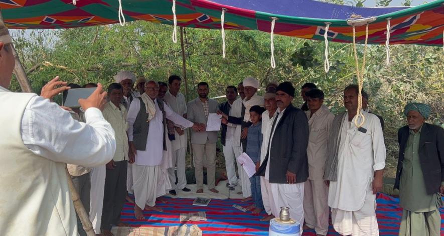
Affected villagers informing the Tehsildar about their problems at the protest site (Photo - Satish Malviya, 101Reporters).
Irrigation Doesn’t Equal Farming
The Narmada main canal’s length in Rajasthan is 74 km. The total length, along with distributaries and secondary canals, is 1792.67 km.
The 1998 Environment Impact Assessment (EIA) report for the canal project mentioned that flood irrigation may cause waterlogging in most of the command areas in a few years, “rendering fertile land unsuitable for agriculture.” As per the suggestion of the Water and Power Consultancy Services Limited (WAPCOS), which conducted the EIA, micro irrigation techniques like sprinklers and drip irrigation were made mandatory in the two districts.
As per WAPCOS’ advice, water allowance for irrigation was reduced from 7.41 cusecs per thousand acres to 1.31-2.51 cusecs. The agency also suggested tree plantation along the canal banks to prevent waterlogging.
Not much was put into practice, though.
“The plan was to supply water from the Narmada main canal to the minor and then the sub-minor canal, from where water was to be supplied to the farmers’ fields through underground pipelines through the diggi system,” said Ishraram Bishnoi, farm leader and president of the Diggi Committee of Chitalwana block. A Diggi is a sub-minor canal connected to a tank. A pump set in the tank is used to lift water to individual farms via underground pipes.
“Nearly 80% of diggis in Chitalwana are not working. The underground pipes are of bad quality, and many pumps are still not electrified,” said Bishnoi.
A 2016 report by the CAG says that only 55% of diggis were electrified till then.
Farmers in the Nehad area are small and marginal and couldn’t afford the cost of a sprinkler system. In the absence of functional Diggis and a sprinkler system, they initiated flood irrigation from canals directly. “People were only too happy to get canals in this dry belt. They didn’t understand the risks back then. Now, freshwater from the canal mixes with alkaline soil and the high rate of evaporation leaves salt on the surface,” said Bishnoi.
As per rules, farmers can irrigate only 50% of their total land, Ishraram told 101Reporters. “But in the greed for higher yield, farmers divert maximum water from the canals into their fields. There is theft of water from the canal. People whose fields are closer to the canal sell water illegally, charging up to Rs 10,000 for watering the cumin crop in one season. The government tax, on the other hand, is only Rs 30/ha.
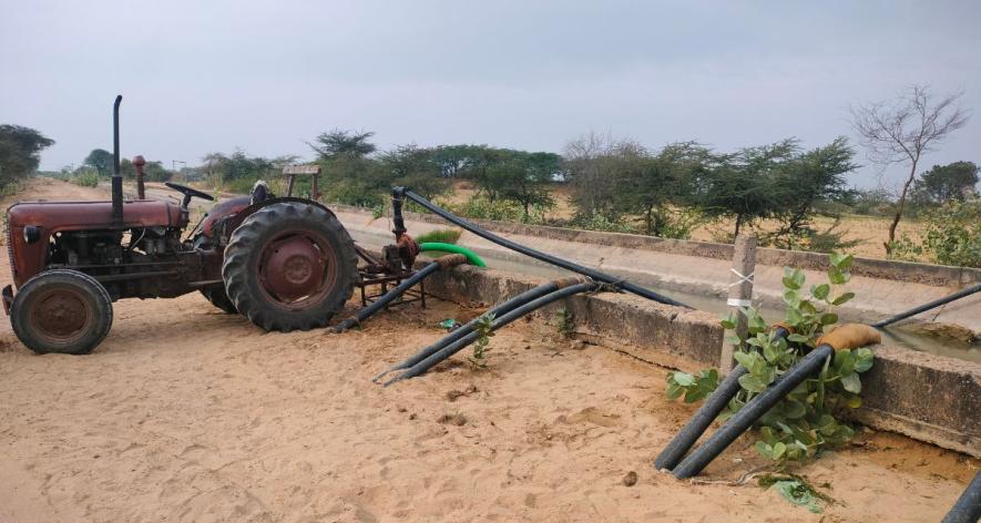
Water theft using a tractor pump from the canal (Photo - Satish Malviya, 101Reporters).
Climate Change Adds to the Soup
The canal network, combined with the underground gypsum belt, has increased the water table in the area. The Narmada project EIA said that in the Nehad area, “fresh groundwater flows as a narrow sheet of thickness over the saline groundwater below.”
“In the last 10 years, the pattern of rain has also changed in Barmer and Jalore. The annual rainfall, which was earlier 256 mm, has now gone up to 350 mm. There were three flash floods in this period. Humidity has also gone up. This has resulted in pest attacks on crops,” said Dr. Pradeep Pagaria, scientist at Krishi Vigyan Kendra, Gudamalani in Barmer.
“Uncontrolled irrigation will lead to many problems. As it is, the area under cultivation in the region has gone up six times, due to which grasslands have vanished and many indigenous grasses have become extinct,” said Dr. Pagaria.
Residents informed that endangered wildlife in this region- black bucks, wild cat, desert fox, and spiny-tailed lizard are hardly seen anymore. “People set up electric fences to ward off wild animals who lived in the grass earlier,” informed Chaudhary.
In 2008, CAZRI, while studying the adverse environmental impact of the Narmada canal project, knew that the canal system would worsen salinity in the region, but also said the area has good potential for controlled irrigation due to moderate drainage and deep soil. “Irrigation in the Luni Delta requires adequate control measures and close monitoring of water use at the farm level, especially to prevent the build-up of salinity in the root zone of the soil. Now that the Narmada Canal is there, there is no escaping its use (and possible over-use) by farmers,” said Amal Kar, former principal scientist at CAZRI.
Satish Malviya is a freelance journalist and a member of 101Reporters, a pan-India network of grassroots reporters.
Get the latest reports & analysis with people's perspective on Protests, movements & deep analytical videos, discussions of the current affairs in your Telegram app. Subscribe to NewsClick's Telegram channel & get Real-Time updates on stories, as they get published on our website.