Frequent Floods and Landslides in Kerala Raise Concerns
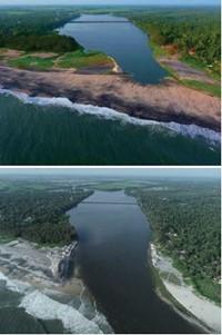
Before (top) and after (bottom)Thottappally estuary was widened a few months back under the same project. Courtesy: R Ramakumar
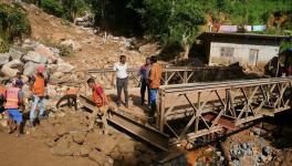
When the rains falling over Kerala for the previous few days intensified in some areas on October 16, people in the districts of Idukki, Kottayam and Pathanamthitta were caught unawares by the torrential downpour and the resultant flash floods, mud slips and landslides. At least 55 people lost their lives, and hundreds of houses were destroyed as a result of the rains that battered the state.
Kerala has experienced extreme inundation over the last few years. In fact, after droughts in 2015 and 2016, the state has faced one disaster after another – Cyclone Ockhi in 2017 and extreme weather events resulting in severe floods in 2018 and 2019. The floods in 2018 were the most powerful that Kerala had witnessed in nearly a century. Around a sixth of the population and 1260 out of 1664 villages in the state were directly affected. Over 480 people died, with damages running into lakhs of crores of rupees.
If the extent of devastation in 2018 was due to significant excess rainfall in August after a high wetness condition before it, sudden intense rainfall caused widespread flooding and landslides in 2019. Over two lakh people were displaced and the death toll crossed 120 that year. And in August 2020, relentless rainfall for over a week in Pettimudi in Munnar resulted in a particularly disastrous landslide that killed 70 people. Pettimudi had never reported a landslide in recorded history and neither was it considered prone to one.
Repeated extreme rainfall and associated events, along with their sudden nature (and hence, unpredictability), have led many in the state to point fingers at climate change due to the impact of global warming. According to the India Meteorological Department (IMD), cumulative rainfall in Kerala in the month of October this year amounted to 589.9 mm, a 94% increase from the normal level.
In fact, the state has already received 20% excess rainfall over the last one month alone than what it usually receives annually from October to December. This is despite the fact that the northeast monsoon, which accounts for the bulk of rainfall during this period, has only arrived a few days ago.
IS CLIMATE CHANGE THE CAUSE?
“The heavy rainfall experienced this time was a localized phenomenon, triggered due to the formation of a low-pressure system in the Arabian Sea,” says B Chakrapani, Associate Professor at the Department of Atmospheric Sciences, Cochin University of Science and Technology. Earlier this year, a team of researchers including Chakrapani had published a paper that had concluded that the floods in 2019 were associated with a mesoscale cloudburst event, which is very rare and has not been recorded in the region ever since the collection of meteorological data started, pointing to structural changes in monsoon clouds over the west coast of India.
According to Chakrapani, there has been a rise in the sea surface temperature of the Arabian Sea in recent years and an increase of 1°C results roughly in 6-7% of excess moisture in the atmosphere. This has also meant that cyclonic activity has increased in the region, he added.
In May, Cyclones Tauktae and Yaas had hit the coast of Kerala, resulting in record-breaking rainfall. As existing weather models cannot forecast extremely heavy rainfall in the tropical weather system with a high degree of precision, both authorities and the local population don’t get enough time to take precautionary measures.
“There is no consensus, however, on whether climate change is the exact cause of these extreme weather events,” says Goutham Radhakrishnan, a researcher on climate policy at MS Swaminathan Research Foundation. The recently-released Sixth Assessment Report on Climate Change by the Intergovernmental Panel on Climate Change (IPCC) also shows the limitations of attribution studies.
According to the report, “near-term changes in monsoons, both at the global and regional levels, will be dominated by the effects of internal variability (medium confidence).” However, “monsoon precipitation is projected to increase in the mid-to-long term at a global scale, particularly over regions including South and Southeast Asia (high confidence).”
Whether recent extreme weather events in Kerala have been caused by climate change arising out of global warming or not, the devastating impact they have had and the likelihood of their recurrence points to the need for long-term solutions.
BIODIVERSITY AND THE GADGIL REPORT
The recent extreme weather events have brought back heated debates in the state over the Gadgil Report and its implementation. The Western Ghats Ecology Expert Panel (WGEEP) headed by Madhav Gadgil submitted its report to the Union Ministry of Environment and Forests ten years ago, triggering widespread protests in Kerala and bringing out the contradictions between environmental protection and human development. Now, the increasing frequency of floods and landslides has prompted many environmentalists and activists to question why the recommendations in the report are not being implemented.
However, not everyone accepted the recommendations of the panel fully, as was evident in the scale of the protests. The Gadgil commission was not tasked with finding the causes of floods and landslides or to recommend measures to respond to them, but to assess the ecological status of the Western Ghats region, classify sensitive zones and propose measures to regulate them, Radhakrishnan points out.
A 2015 article published in the Economic & Political Weekly, co-authored by Radhakrishnan, calculates that over one-third of the area and half the population of the state come under areas marked as ecologically sensitive zones by the report.
“A high amount of cultivable land, both irrigated and un-irrigated, are part of these zones and so are highly urbanized areas including entire towns. Both the Gadgil report and the Kasturirangan report that came later do not have a detailed demographic analysis of the affected areas and don’t mention the impact of their recommendations on the livelihood of the concerned population,” says Radhakrishnan. “There should be a science-based political consensus so that environmental concerns are balanced with the peoples’ right to a dignified life, he adds.”
However, Radhakrishnan agrees that long-term measures will be needed to tackle the destruction caused by repeated extreme rainfall events. “There should be a comprehensive geomorphology study and vulnerability mapping in order to find out how floods and landslides can be tackled,” he suggests.
THE ROOM FOR PAMBA PROJECT
One such long-term solution that the Kerala government has launched is the Room for Pamba Project. The project is part of the Rebuild Kerala Initiative, through which the state government aims to ensure ecological and technical safeguards, so that rebuilt assets can withstand floods in the future.
Modelled on the Room for River project implemented in over 30 locations across the Netherlands by the Dutch government, Room for Pamba aims to end flooding in the most flood-prone region of Kuttanad by creating space for the water in Pamba River to flow. Proposed measures included cleaning the Pamba River, widening the estuary, removing the sandbar at Thottappally spillway and removing obstructions along the stretches of the river to give it more room to flow.

Before (top) and after (bottom) the sandbar was temporarily removed from the Thottappally spillway last year under Room for Pamba project. Courtesy: R Ramakumar
“The project has already started showing results and Kuttanad was not flooded this year,” says R Ramakumar, member of the Kerala State Planning Board and lead author of the report on the Kuttanad package that incorporates the Room for Pamba Project. 75,000 cubic metre of sand and debris were removed from the river last year by dredging. Deepening and widening of the Thottappally estuary was completed by the Irrigation department in July this year, with the width of the estuary mouth increasing from 190 metre to 360 metre.
“The sandbar at Thottappally spillway is being removed and a report by IIT Madras on aspects of the work to straighten a stretch of the river is being awaited,” said Ramakumar. Chief Minister Pinarayi Vijayan stated in the state Assembly that by taking these measures, the intensity of flooding in the region had been brought down considerably. “The next phase will involve the widening and deepening of canals,” he said.
The government plans to finish the ongoing projects in Pamba and Vembanad before coming up with tailor-made solutions for other rivers. Such localized solutions incorporate measures of water management that allow for the practice of multiple occupations in the region, such as agriculture, fisheries, animal husbandry and tourism. There are 44 major rivers in the state and around 10 of them are prone to heavy flooding.
Besides, the government will also have to look at land-use policies, building controls and regulation of mining practices in vulnerable areas as recommended by the expert committee that had been constituted to investigate the cause and responses flooding and landslides in 2018 and 2019. It has its task cut out.
Get the latest reports & analysis with people's perspective on Protests, movements & deep analytical videos, discussions of the current affairs in your Telegram app. Subscribe to NewsClick's Telegram channel & get Real-Time updates on stories, as they get published on our website.


